


Mapping the Shetlands: Explore Scotland’s Untamed Archipelago
The Shetland Islands are an awe-inspiring archipelago located off Scotland’s northernmost coast, where the wild North Sea meets the Atlantic Ocean. A land of dramatic cliffs, rolling moorlands, and remote fishing villages, Shetland is made up of about 100 islands, of which only 16 are inhabited.
Situated approximately 170 kilometers (105 miles) north of mainland Scotland and closer to Norway than London, the Shetland Islands have a unique geographical and cultural identity shaped by Viking heritage, maritime history, and stunning natural landscapes. Whether you’re planning an adventure or simply curious about this remote archipelago, understanding the Shetland Islands map is key to unlocking its secrets.

Understanding the Shetland Islands Map
The Shetland Islands cover around 1,468 square kilometers (567 square miles) and are scattered across the North Sea in an irregular, windswept formation. While the islands share a similar rugged terrain, each has its own distinct features, from towering cliffs to fertile pastures and secluded beaches.
The largest island, known as the Mainland, serves as the hub of activity, with the capital town of Lerwick at its heart. Surrounding it are a series of smaller islands, each with its own charm and history.
Let’s break down the geography of the Shetland Islands by region:
Mainland Shetland: The Heart of the Archipelago
Mainland Shetland is the largest and most populated island, stretching about 100 kilometers (62 miles) from north to south. It’s known for its rugged coastline, inland lochs, and rolling peat-covered hills. Key locations include:
- Lerwick – The capital of Shetland and the main port, Lerwick is home to historic sites, bustling harbors, and the Shetland Museum & Archives.
- Sumburgh Head – Located on the southern tip of Mainland, Sumburgh Head is famous for its dramatic cliffs, seabird colonies, and a historic lighthouse.
- Scalloway – Shetland’s former capital, Scalloway is home to the ruins of Scalloway Castle, built in the 1600s.
- Eshaness – On the west coast, Eshaness boasts some of the most stunning sea cliffs and rock formations in Shetland, shaped by powerful Atlantic waves.
Mainland Shetland is divided into several regions, including North Mainland, South Mainland, and West Mainland, each with unique landscapes and cultural attractions.

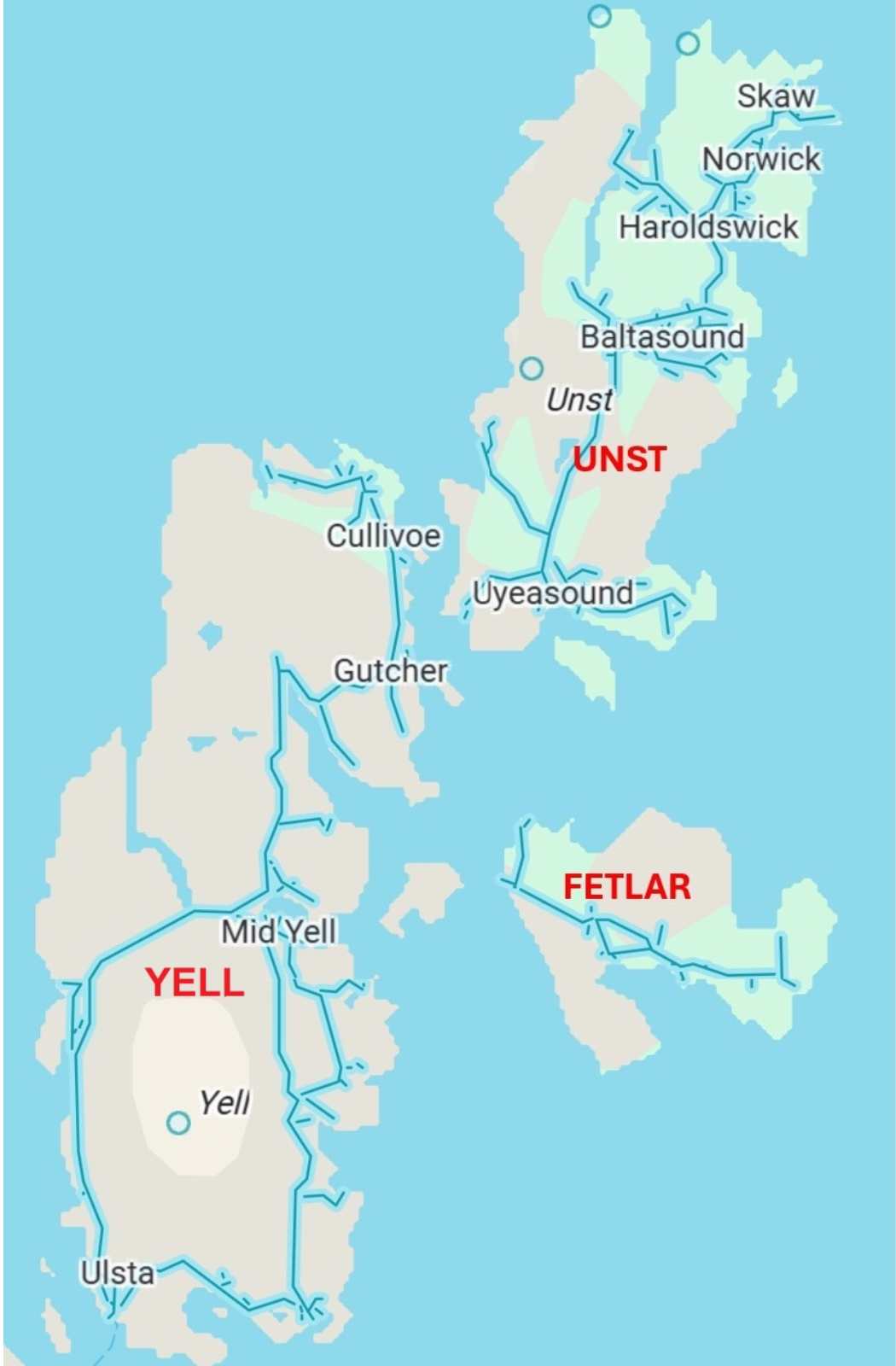
North Isles: Wild and Remote
The North Isles of Shetland are sparsely populated and offer breathtaking scenery and abundant wildlife.
- Yell – The second-largest Shetland island, Yell is known for its windswept moorlands, dramatic coastline, and otter populations.
- Unst – The northernmost inhabited island in the UK, Unst is home to the Hermaness Nature Reserve, where visitors can see puffins, gannets, and great skuas (bonxies).
- Fetlar – Known as the “Garden of Shetland,” Fetlar has fertile land, stunning beaches, and is a prime location for spotting red-necked phalaropes, one of Britain’s rarest birds.
West and Central Shetland: A Landscape of Lochs, Cliffs, and Hidden Gems
The western and central parts of Shetland are characterized by dramatic sea cliffs, rolling moors, and deep lochs.
- Papa Stour – One of the most geologically significant islands in Shetland, Papa Stour is famous for its sea caves, arches, and stacks formed by volcanic rock.
- Walls & Sandness – Located on the western edge of Mainland, this area is a haven for seabirds and marine wildlife.
- Burra Islands – Connected to Mainland by a series of bridges, the Burra Islands (East and West Burra) offer a more sheltered, picturesque version of Shetland life. These islands boast sandy beaches like Meal Beach, colorful fishing hamlets, and quiet walking trails. Although close to Lerwick, they retain a tranquil, rural character that feels worlds away.

South Shetland: History and Wildlife
The southern part of the Shetland Islands is rich in history and offers some of the best opportunities for wildlife spotting.
- Mousa – This small island is home to the best-preserved Iron Age broch in Scotland, Mousa Broch, which stands over 13 meters tall.
- Fair Isle – Known for its famous Fair Isle knitwear and seabird colonies, this tiny island is a paradise for birdwatchers and nature lovers.

Outer Shetland: Isolated, Untamed, and Otherworldly
Some of Shetland’s outer islands are among the most remote places in the British Isles.
- Foula – The most isolated of the Shetland Islands, Foula is known for its towering sea cliffs, Norse heritage, and a tiny population that still follows Old Norse traditions.
- Whalsay – A thriving fishing community, Whalsay is often called the “Bonnie Isle” for its beautiful landscapes.
- Out Skerries – The Out Skerries are Shetland’s easternmost islands, a cluster of small isles lying far out in the North Sea. With fewer than 50 residents, the Skerries are rich in Norse history, shipwreck tales, and dramatic rocky coastlines. They’re a dream for lovers of maritime lore and remote, off-the-beaten-path adventure.

Shetland's Coastline and Marine Features
The Shetland Islands’ rugged coastlines are shaped by powerful waves, strong tides, and relentless winds. Shetland has over 2,700 kilometers (1,680 miles) of coastline, with numerous fjords, inlets, and natural harbors.
Notable coastal landmarks include:
- St. Ninian’s Isle – Connected to Mainland Shetland by one of the UK’s best tombolos, a sandbar that joins the island to the mainland.
- The Ve Skerries – A treacherous group of rocky islets west of Shetland, known for shipwrecks and dramatic waves.
- The Noup of Noss – A spectacular seabird colony on the uninhabited island of Noss, home to thousands of gannets.
Why Explore Shetland?
Shetland’s geography makes it one of the most captivating destinations in the UK. From prehistoric sites and Viking heritage to wildlife-watching and dramatic landscapes, the islands offer something for every traveler.
If you’re planning to visit, make sure to have a detailed map of Shetland to navigate its remote roads, ferry routes, and walking trails.
More from
European Islands
Category

